The history of war art has an ancient pedigree dating back to before early Egyptian times while the importance of this art form has long been recognised, not least by governments who have sought to utilise artists’ skills specifically for the furtherance of the war effort.
In Britain, for example, an official war art scheme was set up during the 1914-18 war which continued right up to the Falklands war, a unique experiment in Government patronage that has produced an unrivalled national collection of paintings, drawings and pieces of sculpture. Although theoretically employed by their governments as propagandists, many of these official war artists would go way beyond their original brief, producing work of genuine artistic merit.
An obvious example of this is the artist Paul Nash who joined the Artist’s Rifles in the First World War. Initially motivated by a straightforward patriotism, his belief in the rightness of war would, in time, begin to crumble as he was exposed to the horrors of trench warfare. His subsequent paintings of ravaged landscapes with trees shattered by shellfire bear comparison with the best of the war poems in their depiction of the nightmarish conditions in which the soldiers were forced to fight.
(Needless to say, Nash’s employers were less than enthusiastic about his work.)
Not all war artists are, of course, engaged in this capacity. Many self-employed ones take up the practice for more personal reasons – an interest in war from an emotional, social and psychological point of view or simply to produce a pictorial record that can be studied and interpreted by posterity, a mirror of the times.
The well-known Southern African war artist, Peter Badcock slots comfortably into this latter role. Having grown up in the region he fell into the business of war art almost by chance when he found himself serving in the Rhodesian security forces and decided to put his skill as an illustrator, working in an animation studio, to good use by producing a book about the conflict. The gamble paid off. Published in 1978, Shadows of War was an immediate success. Encouraged by its reception he would go on to bring out two more bestsellers covering the conflicts in white-ruled Southern Africa– Faces of War (Rhodesia – now Zimbabwe)and Images of War (South West Africa – now Namibia).
His latest book, A War Artist’s Diary, is essentially a distillation of these three books but also includes a realistic appraisal of the two wars – as well as his involvement in them – written from the vantage point of hindsight. Beautifully produced, and including 100 of Badcock’s best drawings, as well as a selection of his evocative poems, it provides a vivid, almost documentary-style, account of life in a war zone.
In his art, Badcock aims for a scrupulous integrity, although it is obvious that his association with the army necessarily influenced the subject matter available to him. As he writes in his introduction, the drawings are “not intended to eulogise or defend either side in the tumultuous history of these events but to capture the human dimension of men and women at war”.
Badcock deserves full credit for achieving just this. His drawings have an almost photographic accuracy of representation. They record not only the conflicts themselves but the life going on around the fighting, a sort of behind-the-scenes view of people going about their ordinary work in extraordinary circumstances.
Published by Simon & Schuster
Over 150 000 years ago mankind diverged from the cradle of the African plains and began spreading over the globe. This trend has continued until the present day and has been followed by “convergence” as disparate communities re-established contact with each other. What this ought to tell us is that migration is not an aberration or something you only undertake under duress. It is an essential component of the human condition, a natural urge, part of our make-up. It is, as it has always has been, about the pull of opportunity.
Despite this, there has been, especially in recent years, a great deal of nativist, anti-immigrant sentiment, much of it stirred up by populists of the Donald Trump ilk who insist on referring to it as “foreign invasion”. In this fascinating and thought-provoking book, author Felix Marquardt takes issue with such views arguing that, in many cases, it is in our best interests to welcome newcomers and share our spaces. As he points out, a new generation of migrants, well-educated, tuned in through their smartphones to global events, entrepreneurial and full of ideas have come into being and we would be foolish to turn them away.
Also, contrary to popular belief, most of these immigrants don’t sink into poverty or live in dingy apartments in high crime neighbourhoods. Rather, they have contributed to and flourished in their new countries because of their work ethic and determination to carve out a new life. Others have taken hazardous or poorly paid jobs shunned by the native-born and helped grow the economy that way.
Nor are all migrations necessarily about poor people heading to richer countries. The author cites many examples of the reverse – where young people, stifled or not seeing a future for themselves in the country of their birth, have moved to places like Africa where they are still trying to develop and modernise their economies and it easier to build something up from scratch. Technological advances have also led to increased mobility. These days you can, with a computer, do your work anywhere. For the author, these acts of migration can be transformative, it can teach you to open your eyes and ears to other people and grow from the experience.
Writing, in part, from his own experiences as a person of mixed heritage who has called many different countries ‘home’, the author has made an important contribution to the whole migration debate. Going beyond the usual headline cliches about helpless refugees, he finds a far more complex and, in the end, positive story. Amid the thought-provoking broad-brush picture, Marquardt also wields a vivid miniaturist’s pen as he describes the people involved in these modern- day migrations – those he calls the New Nomads.
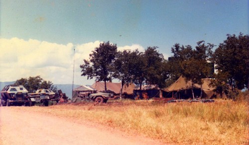
That morning, I was woken by the alarm of bird calls; the sky was turquoise, becoming lighter close to the pencil-line horizon. I levered myself upright and began putting on my boots. Motionless, the land lay stretched out below me.
Charged with the army’s acrid coffee, I was sitting up against a large boulder enjoying the cool, morning air when the quiet was punctured by the dry snapping of rifle fire on the valley floor below. It didn’t take me long to grasp what had happened. One of our patrols had got caught up in what sounded like a very serious firefight.
Almost immediately our radio crackled into life. ZANLA forces had been encountered in large numbers. Our orders were to sweep down from our OP (Observation Point) in the foothills of the Mavuradonha Mountains and attempt to engage them from the rear (they had fled by the time we got there but they came back later and found us).
As I grabbed my rifle and webbing and slung on my backpack I found myself thinking, once again, about the weird unreality of it all. How in the hell had I, a pacifist by nature, managed to get myself mixed up in this vicious bush war? Landed in this strange situation where the unfamiliar had suddenly become familiar?
It was not a war of my choosing, nor one I particularly wanted to be part of. Even today I still cannot adequately explain why I stuck it out until the bitter end of the conflict and carried on fighting long after many of those who had believed far more passionately in the cause than I had decided to call it quits – “gapped it” to use the slang of the day – and left the country. It is also no use pretending I was anything else but an extremely reluctant soldier or that I showed any real aptitude or talent for military life. Indeed, for the most part, I never felt I was anything more than a resentful, inadequate, half-trained civilian.
Looking back across the years I sometimes have difficulty recognising that man in the grubby camouflaged kit as myself; there is an abiding strangeness about it all. It is as if I am looking into a broken mirror and all those experiences happened to someone who looked like me but was in fact an impostor. For me, the past is, indeed, another country.
An abiding strangeness. At Marymount Mission, in the extreme North-East of thecountry, near where the Mazowe River crosses into Mozambique. This was on my last call-up.
And yet, now that I reflect back on it, I realise the army was not all bad. It had some value. Firstly, it tested me in ways I would never have otherwise known. I learnt about physical and mental hardship, about dealing with extremes and staring into the abyss. I discovered what it was like being stripped down to my most basic self. At various stages, I was the hottest, coldest, most tired, thirstiest, hungriest, terrified, angry and miserable (but not the happiest) I have ever been in my life.
The fact that I survived these in extremis tribulations and emerged from it frayed, disenchanted and proud afterwards was, I suppose, an achievement of sorts.
Secondly, the army took me into areas I would have not otherwise seen and in so doing heightened my appreciation and love of the African landscape. In some perverse way, all the discomfort, fatigue and fear I experienced during those war days became a form of mini catharsis; it made me feel more part of the bush. We even had a term for it, one that suggested a temporarily disarranged self – one became “bush happy”.
The landscape affected me in other ways. Not sure whether my role was that of the hunter or the hunted I found my senses becoming sharpened to the sounds and smells of the bush. Far from the comforting normality of civilian life, I became increasingly feral in my habits, always watching and listening for anything that might threaten my chances of getting out alive.
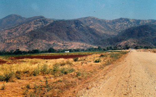
For much of my initial national service – and in the subsequent seven years of military call-ups – the regiment I was with operated in the extreme North-East of the country, an area where civil administration, outside a few sandbagged strong points, had all but broken down. Not too far from the border with Mozambique, it was among the harshest and most rugged landscapes in all of the then Rhodesia and, along the escarpment itself, virtually uninhabited.
Assembly Point Alpha, Hoya, near Mozambique border, 1980. Mavuradonha is in the background. It was here my war came to an end…
What always struck me most about this landscape – apart from the heat and general sense of discomfort – was the feeling of immensity it evoked. Behind us, the Mavuradonha Mountains rose in a steep pitch from the Zambezi valley floor while ahead of us a vast plain stretched out almost without undulation. And beyond that lay more of the same, hundreds and hundreds of kilometres of raw, unspoilt, and untrammelled country leading up through Mozambique and then into the rest of Africa.
Mavuradonha, near Mzaribani. I took this pic on a return trip several years after the war ended.
The more time I spent in it the more I began to see the beauty in the timelessness and silence and hugeness of the land. The sheer vastness of it seemed to be immeasurably increased by the dryness. Then there was the silence, broken only by the occasional bird song or jackal howl at night or a sudden gust of wind blowing in waves of warm air. It is a kind of silence you just don’t get in the normal, urban world with its bustle and false pleasures.
This, in turn, brought with it a vague feeling of loneliness, a sense of being cast off from familiar moorings, an awareness that there was no one else within easy reach. Strangely enough, this only added to its appeal.
Operating in this sort of country was never easy. In summer the heat could be stupefying. Weighed down by my heavy pack and ammo I could feel the sweat trickling down my back and soaking my shirt. It chafed between my thighs.
On patrol.The bicycle we found abandoned in the middle of nowhere…
Thirst could plague us like a nagging toothache. We had to develop the will to endure it. Because we only carried a couple of bottles each, I was forced to restrict it to little sips. On several occasions, I suffered from severe leg cramps. Most awful of all was the time I collapsed from heat exhaustion and complete dehydration. My legs refused to function, my tongue became dry and swollen, like an old piece of leather while my throat felt like it was coated with fur.
If it wasn’t for a spotter plane that picked up our distress call and later returned to drop water, I often wonder if I might ever have got out…
The heat was not the only thing we had to contend with. The Shona word Mavuradonha roughly translates as Land of Falling Water and as the season progressed you could understand how it got its name. After months of nothing but sun and dust, the weather would begin to change. It would grow more unsettled and windy, moving smells around. Tall, purple-bottomed clouds would build-up to the north.
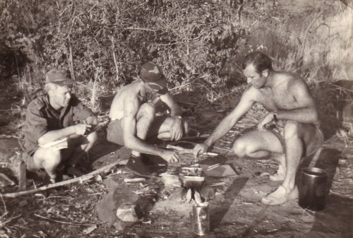
Once the rains broke we were put through the whole gamut: heavy rains, moist, intermittent rains, a half-hour sprinkle, a thundershower, drizzle. Our clothes and equipment became cold, damp, smelly. At night we had to endure all the discomforts as it poured down on us. Now and again, especially in the early stages of the storm, the darkness would be torn away for a second by a dazzling flash of lightning which would bathe the surrounding bush in a strange, otherworldly light. Then the thunder would roll, like the sound of cannon fire, and we would lie there dazed and stupefied and shivering in our sopping wet sleeping bags while the rain came pelting down around us.
Usually, the storm would pass as quickly as it came, the wind would die down and we would do our best to get back to sleep. In the morning the sun would shine through the wet leaves to where we lay sodden and miserable. Once we had dried out our gear and re-oiled our rifles we would continue on our patrol.
We couldn’t drop our guard. Such is the nature of guerilla warfare that we never really knew who we could trust – if, indeed, we could trust anyone – amongst the local civilian population. In most villages we visited the response was usually muted – neither friendly nor unfriendly. It was difficult to know, too, who the locals were more scared of offending – us or the other side. Many, accused of being “sell-outs”, had been arbitrarily killed by the guerillas as a warning of what would happen to those who chose to betray them. Others had been caught in cross-fire between the opposing forces and died that way.
While the more cautious hedged their bets, I am sure many did want to see a more representative government, one not made up solely of whites. For all we knew they could be in direct contact with the ZANLA forces, maybe even feeding them and passing on information about our movements.
In this sense, the war had already begun to highlight something of considerable political significance – it provided the ultimate test of the black “povos” ( English translation: the masses, the common people) real feelings. Although it helped, of course, to be armed we could never quite escape this sense of hidden danger or that, outside of our fellow soldiers, there was no one we could rely on.
Mavuradonha, view from the infamous Alpha Trail, scene of many ambushes and – before it was tarred – landmines.
For the most part, we operated in five-man ‘sticks’ sometimes linking up with another stick at night for added security. Patrolling in such small groups through a potentially hostile country, where the loyalty of the locals could not be relied on, I did my best to keep my eyes open, my mind alert to my surroundings or any movement in my peripheral vision. Alone like that, it was easy to feel eyes watching us, indeed the suspicions of being followed and watched became a constant companion. The uncertainty weighed on our minds.
Towards evening we would usually stop for one last brew-up before moving into our final position for the night. It was the time of day I liked most. There is something about the dissipating violet light as the sun sinks which makes everything seem, holy, natural and familiar. It is a time when earth, rock and sky seem to marry, a time when surrounded by the great wall of the mountain the landscape seemed to acquire an uplifting, transcendental quality. I could feel its beauty penetrating my soul. It made me feel grateful for being alive, grateful for having survived another day, grateful that I would shortly be able to sleep.
Cook-up time in Zambezi Valley.
Far from the big city lights or man-made pollution, the night swarmed with stars while the sky above us seemed bigger than any I had ever seen before. Sitting in the middle of nowhere, staring into the enormity of space and feeling, in the most animal sense, my infinite littleness it was often hard to make sense of all. Perhaps that was the point of it. To make us feel very small, to remind us that we are just a speck and that our time on earth is short and fleeting.
Of what importance was I, caught up in this forgotten, war, in the grand scheme of things? Like many a soldier before me, I was forced to acknowledge the helplessness and insignificance of my lot – while at the same time cursing the old folk who had got us into this jam.
Not that these moments of philosophical introspection lasted long. Where, the night before, the world had seemed ethereal, dream-like, in the morning light I was only too aware of its hard contours, its physicality and my sense of discomfort.
One experience, in particular, still haunts my memory. It was our first major cross-border excursion into Mozambique, an exhausting march not made easier by the fact I was suffering from severe diarrhoea during the high summer heat and only had a limited amount of water to drink. There was something strange and spellbinding about crossing into an enemy country. It was like we had been passed through more than just a physical boundary. We had entered another dimension, reached the very edge of the known world. Civilisation, as I knew it, seemed a very long way away.
The further we penetrated, the more cracked, bleached, and wild the country became. The heat left me breathless. After days of tramping through the dry, Mopani-dominated scenery the vegetation suddenly began to green up and thicken and in the distance, we could make out the unmistakable sound of flowing water. We had reached the Zambezi.
The broadening river was full of cigar-shaped islands covered with reeds. Tall vegetable ivory palm trees, massive Ana trees and Natal Mahogany’s dotted the far shore under which grew a mass of riotous vegetation. Fed by several additional large tributaries the river had grown even wider and more powerful and imposing than the one I was familiar with, stretching out before us like a rumpled sheet of blue vinyl and measuring a good kilometre or two from side to side.
The emptiness of the country we had passed through was reflected in the emptiness of the river and its banks. There were no signs of human activity: no men polling along in dugouts, no fishermen, no women washing, no children playing on the water’s edge and no domestic animals. Indeed, the scene before us had probably changed little since David Livingstone and his mutinous crew came steaming up the river in the Lady Nyassa all those years ago.
The landscape itself – aside from the river – was similarly devoid of feature. No cliffs nor distant mountains were framing the river valley. There were few roads or paths to follow and the odd villages we passed through had long since been deserted. It all seemed strangely peaceful. For all intents and purposes, it appeared to be uninhabited although we knew were not alone. Somewhere out there was not only ZANLA but the Mozambique resistance movement, Frelimo, as well.
That thought kept us on our toes.
Reluctant to leave the cooling shade of the river we lingered as long as we could before turning around and heading back to our extraction point where we were due to be picked up and choppered back to our military base in Musengezi, just across the Rhodesian border. We could see no sign of life from the air either as we flew over the baked, engulfing landscape; just trees and more trees stretching from horizon line to horizon line.
Helicopter pick-up in typical dry season Zambezi Valley bush.
So undifferentiated was the landscape that if not for the occasional baobab, I would have lost all sense of perspective. Looking like prehistoric animals with enormous bodies and a multitude of limbs spreading out laterally, as if they wanted to pluck us from the sky, they towered above the surrounding trees.
As we skimmed over their outstretched branches, I remember thinking to myself that winning a war in this sort of country would be virtually impossible. All the enemy had to do was stage hit and run attacks and then allow themselves to be swallowed up by the empty space where no one was likely to notice them because there were so few people to notice anything and those that there were would be unlikely to be in any hurry to trek to the nearest Security Force outpost to report what they had seen.
Time, the Great Revealer, would prove me correct on this point…
The Great Fish River Valley near Committees Drift.
It is already early afternoon when I pull over on the top of the Nico Malan Pass, which drops a massive 673 vertical metres over 13,8 kilometres, into 1820 Settler Country. Taking a sip of the now lukewarm coffee in my Thermos, I look at the raw landscape around me. To my right, capped by a bluff of rock, are the Katberg which, in turn, become the Winterberg. To my left, the rest of the mountain chain stretches away toward the Hogsback and the Amatola.
The Katberg
Above me, I can see the pale puff of rain clouds receding over the mountain tops. The very air looks grey and dampness seems to rise up off the tarred road like mist. The road ahead tapers away through miles of dry East Cape thicket, sprinkled with aloes, euphorbia, succulents, sweet thorn, and spekboom..
Although I was not born here, I am, in a sense, back where it began, my home patch. It was here that many of my ancestors settled when they came to South Africa, way back in the early 1800s.
The first was Benjamin Moodie, the Seventh and last Laird of Melsetter in the Orkney Islands whose family fell upon hard times and who sailed from London on the brig Brilliant in March 1817, arriving at the Cape in June. From there he trekked up to Grootvadersbosch in the Overberg where he hoped to recreate his bit of feudal Scotland in the shadows of the Langeberg. It was his grandson, Thomas (Groot Tom) Moodie who led the Moodie Trek into the then Southern Rhodesia which explains how I came to be born and raised up there, among the beautiful Nyanga mountains.
And why I am driving down this road today.
Then there were the Nesbitts (my father’s mother’s side of the family), from Ireland, whose history I have only recently discovered, but whose story I am now trying to follow. Other ancestors too – the Colemans, the Arnotts, the Stirks as well as my immediate kin, the Stidolphs. All spent time in the Eastern Cape area.
As I descend the winding road that leads, through Seymour and Fort Beaufort, into the vast Great Fish River Valley, I feel my senses heightening, flaring. I look and listen, feel the air, try to see the country as they did, all those years ago. Coming from the lush, green pastures of Scotland and Ireland, it certainly must have seemed very different from anything they were used to.
There is an old military blockhouse at Fort Brown, where the modern bridge crosses over the Great Fish River, a reminder of the days when this was all disputed territory. It formed part of a chain of similar forts, strung along the banks of the river, which the British soldiers, garrisoned in them, used to pass messages to one other.
Fort Brown – still a police station.
It is here I establish my first connection. An ancestor of mine, on my father’s mother’s side, Lt Col Richard Athol Nesbitt CB, was posted to Fort Brown, as an inspector, in 1875. Later he would go on to form Nesbitt’s Horse which fought with distinction in both the Frontier and Anglo-Boer War. There is a memorial honouring their contribution, among others, to the war effort standing in Church Square, Grahamstown.
Monument honouring, amongst others, members of Nesbitt’s Horse.
Having stopped to snap an obligatory photo of the place, for record purposes, I continue on my way, still taking in the country as I go. Hill leads to hill leads to hill and in between is nothing but space and distance. The oceans my ancestors crossed to get here could hardly have been more solitary than this empty country still is.
It gets me thinking about the 1820 Settlers who settled in this region. Innocent of the reality of Africa, they must have been shocked to discover the arid country, with its harsh climate, they were about to settle on was nothing like the rich farm and pasture land that they had been promised by the propagandists back home. Although the land was theirs to do what they would with, there was another aspect the pamphlet writers had chosen to gloss over in their colourful descriptions– the fact that the settlers were to form part of a Government-approved military buffer zone, aimed at keeping the Xhosa on the other side of the Great Fish River. Inevitably they found themselves caught up in an escalating conflict for which they were mostly ill-prepared.
Perhaps not too surprisingly then, many found it too lonely and too harsh a life and, their faith shaken, put the country behind them to return to the comforts of town life. Others persevered; in some cases, their descendants are still on the same farms. For yet others, Africa proved to be a temporary aberration. Anxious to escape the heat, sweat, and weariness of it all, they packed up and sailed back to England.
For my part, I am bound for Grahamstown where my one sister, Sally, lives. It was here that the settlers decided to build their capital and – because the town never grew at the rate envisaged – you can still see many fine examples of colonial architecture and of their early houses (see Picture Library below). It is also now home to Rhodes University, as well as one of the most dysfunctional and corrupt municipalities in modern South Africa.
The military life seems to have run deep in the Nesbitt blood. Richard’s father, Alexander Nesbitt, had enlisted, at the age 19, in the 67th Regiment (South Hampshire) and was stationed for many years in Mauritius before being sent with the Reserve Battalion, in August 1851, to the Eastern Cape on HMS Hermes to participate in the 8th Xhosa War.
Not much is known about him but his wife occupies her own special spot in history, for she was a passenger on the HMS Birkenhead, which was conveying troops of ten different regiments from Ireland to participate in the Border War when it struck a rock near Danger Point on the Cape Coast and sank with a loss of 450 lives.
The sinking of the HMS Birkenhead is, of course, famous in the annals of maritime history because it was here the order “Women and children first…” originated. Safe in a lifeboat, Elizabeth Anne “Annie” Nesbitt and her third child, the self-same Richard Athol, were two of the only 193 survivors.
Many of the places the various Nesbitts (and there were many of them) had lived in while in the East Cape I have visited myself so I feel I have both set and principal actors. What I now need to do is write a few scenes. For a moment I think of going to the military cemetery in King William’s Town where Alexander Nesbitt lies buried but my time is short and I am not even sure where it is, so, instead I elect to explore the Great Fish River basin from where it crosses the N3 and then take the dirt road that backtracks all the way to Fort Brown – a part of the world that had changed little over time.
Frontier Country. The dirt road back to Fort Brown with Great Fish River in the mid-distance.
With its turbulent, blood-stained, history, the Great Fish has always loomed large in my imagination. Like the Zambezi and Limpopo, it is one of those rivers which has acquired almost mythical status.
The first section of the journey takes you along the crest of a ridge with extensive views on both sides. Although you probably won’t see it mentioned in any tourist brochure, I think it is one of the best drives in all of South Africa because of its wildness, its freedom, it’s feeling of immensity, the land sweeping back in great folds all the way to the distant range of mountains on the one side and the deep blue of Indian Ocean on the other.
Not far from Fraser’s Camp, we turn left off the tar onto a gravel road that runs roughly parallel with the looping river. Many of the place names around here carry echoes of their frontier past. Dropping down into the valley, the first settlement to come into view is Trumpeter’s Drift, one of the many strategically sited forts the British built along the Great Fish in an effort to secure the land south of the river. Unlike most of the others, which stand crumbling and neglected, this solid, block-like structure still forms part of a working farm and is in relatively good nick.
Trumpeter’s Drift – old fort on left of buildings.
We drive on. Alongside us, the river continues to follow the most circuitous of routes as it twists and turns its way through the landscape. Countless thorn trees swarm together along its banks creating a dense, impenetrable mass. Swollen by the recent unexpectedly good rains, its soup brown water gushes copiously along. Broken branches, old logs, chunks of floating vegetation, and mud sweep past. In places, driftwood is piled high along the banks.
Great Fish River – flowing fast. Note thorns.
Our next stop is Committees Drift, another military outpost established by the British during the Frontier war of 1819 (the name “committees” is pronounced by locals as “kommetjies” indicating that the origins may be Khoisan or Dutch).
A steel girder bridge, erected in 1887, spans the river at this point. On the other side of it lies former Ciskei, one of the Apartheid government’s grandiose, if ill-conceived, “homeland republics” where the National Party tried to entrench the principle of racial separation. Granted “independence” (but never internationally recognised as such) in 1980 after a rigged election, the idea that it could function as a separate state was, of course, a fantasy that could never work as the South African economy remained dependent on the black workers who lived in remote corners like this. Among the poorest and most neglected areas in South Africa, it was also too small and lacked the resources to ever manage its own affairs and govern itself. It would always be obliged to live in the pocket of its giant neighbour.
Bridge at Committees Drift.
We drive on again, passing a group of smartly attired church-goers as we do. I am not particularly religious myself but I rather approve of the fact that there are people who are still prepared to dress up to please their God. A solitary donkey walks along the side of the road with an air of utmost purposefulness as if it has a fixed destination in mind. A herd of goats scurries off as we approach them and force their way through a farm fence. Because of its large size, the ram is unable to get through and is obliged to reverse out. Mustering all the regal dignity he can he strides off, acting like this was all part of the plan.
Church goersDonkey on a mission. Ciskei on far side of river.Heading to Church through the mielie field…
Ahead, more hills, more flatness while the sun spreads a dry ruddiness everywhere. Occasionally we pass the empty shells of deserted farmhouses, rotting from the top downwards. Eventually, there will be little left to remind you that somebody lived there. Once they stood for Hope in the Future. Now they stand neglected and forlorn, a lonely reminder of the essential sadness and transience of life.
Our plan is to lunch at Double Drift, in the Great Fish River Nature Reserve, another old fort that once housed British troops sent out to Africa to defend the Empire. Completed in 1837, it protected the important route to Fort Willshire and the interior. Although in a rather dilapidated state of repair it, once again, serves as a memorial to a particular moment in South African history.
At the entrance gate to the reserve, we change our mind when we hear how much it will cost us for such a short visit (a substantial increase from when I visited last) so we decide to strike it off our list of Historic Places to Visit and have a tailgate lunch on the side of the road that leads to Kwandwe Private Game Reserve instead.
A tailgate lunch…
I don’t need to remind myself what the fort looks like anyway because Sally has done a beautiful painting of it (for more examples of her work see Sally Scott)
Double Drift fort. Chalk pastel. Painting by Sally Scott.
Entering Kwandwe, a little later on, I get a glimpse of another challenge the English settlers had to face – elephant. Although long shot out in most parts of the East Cape, they have been reintroduced into some of the larger local reserves, such as Kwandwe. We haven’t gone too far when we see one browsing in the dense thicket, his back stained a dusty yellow ochre from the local soil. A few kilometres on we see another, similarly camouflaged.
Elephants are awesome creatures. There is a mystery, a sense of enchantment, behind their wrinkled grey visage and massive bulk. I can watch them for hours. As intriguing as they are, they do, however, make difficult neighbours to live with, showing scant regard for fences or planted crops or humans for that matter. It is not wise to antagonize them.
On the crest of another ridge, we stop for a final look over the Great Fish River Basin. Below us roll plains, speckled with bush, patterned with cloud shadows, receding into the blue haze of the far mountains, indifferent to man. Once again, I feel overawed by the age and might of this old continent. In such a primaeval wilderness, is very easy to believe here is where all life originated.
A final look back.
By sleuthing around in these backwaters, I also feel I am beginning to get somewhere in establishing a link with my past. My discoveries may not be earth-shattering but they are a start. They provide the building blocks upon which my own life had been constructed.
After running a smooth, spirited campaign the Democratic Alliance snatched a historic victory in the hotly contested uMngeni Municipality, receiving 47% of the votes with 13 seats in the council, while the ANC had 39%, followed by the EFF with seven percent. uMngeni is the first municipality to be led by the DA in KwaZulu-Natal.
Outage turned to outrage as Eskom once again implemented load shedding with next to no notice. With the power utilities, woes showing no signs of improving CEO Andre de Ruyter came in for heavy criticism while industry, already battered by the economic effects of Covid-19, continued to suffer.
While politicians tried to make everyone believe that the coalition negotiations were being pursued in the interests of the residents in the country’s 70 hung municipalities the opposite appeared to be true. Rather than being about service delivery or good governance, they were used to advance narrow political interests to the detriment of voters.
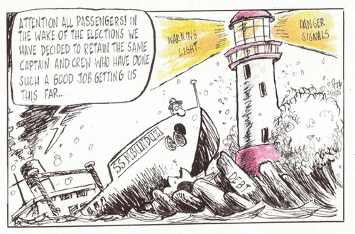
With the reappointment of the old mayor, Mzimkulu Thebolla, and many of the same councilors there was a feeling that nothing much had changed in Msunduzi as a result of the recent municipal elections. In the same week, it was also announced that the municipality was drowning in debt, owing Umgeni Water an outstanding amount of R367 million.
The recently identified Omicron variant had fuelled a worrying surge in coronavirus cases in South Africa and is rapidly becoming the dominant strain, health officials warned. With the imposition of various travel bans to and from South Africa, the government complained it was being punished – instead of applauded – for discovering the concerning new variant of Covid-19.
Despite the fact that the majority of people in hospital with Covid-19 are unvaccinated the roll-out campaign faced continuing scepticism and resistance from a section of the public…
Minister Gwede Mantashe rubbed environmental organizations up the wrong way after saying protests against Shell’s seismic survey along the Wild Coast are examples of apartheid and colonialism of a special type.
While the holiday season should be about sending time with loved ones and doing things we enjoy, the Covid-19 pandemic continued to pose a threat to their health and well-being.
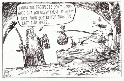
With the highly transmissible Omicron variant having driven cases of Covid-19 to record levels and with no end in sight to the pandemic, the prospects for 2022 do not look good. The one silver lining is that weekly cases appear to be on a downward trajectory.
“If a man does not keep pace with his companions, perhaps it is because he hears a different drummer. Let him step to the music which he hears, however measured or far away.”
Henry David Thoreau
It is probably my British heritage but there is nothing I love more than dashing madly about the countryside, in all types of weather – sunny, showery, cool, breezy – with a pair of binoculars in one hand and a camera in the other. Given this genetic predisposition of mine, it is perhaps just as well I live in an area where it is very easy to feed the habit.
A rambling man...Pic courtesy of Sally Scott.
Kusane is a farm with a commitment to conservation. All I have to do is step out of my front door, skip around the corner of the balcony and then slip across the gangplank that connects it to the ground beyond and I am into the unspoilt, open, pristine countryside. In a moment everything is altered. Any cares or worries I may have quickly get left behind. All my senses come alive. I am agog with anticipation. Another day of happy rambling awaits…
View from Kusane over Karkloof Valley
I never tire of these walks. The countryside is breathtakingly beautiful. There are subtle changes to it every day and every season. These become more pronounced after the first spring rains fall. The colours become more vivid and intense, wildflowers burst through the earth. As the summer storms intensify, the greater the profusion around me. In what seems like the blink of an eye, the deciduous trees start unfurling their new leaves. As sun and rain come together, the lengthening grass shimmies all around me. Great idle puddles lie across my path.
The first Yellow-billed Kites swoop over Kusane. Then swallows and other migrants arrive. They seem happy to be back and they let you know it. The cuckoos start calling, none more so than the ubiquitous ‘ Piet-my-Vrou‘ (Red-chested Cuckoo) who drones on for hours on end, often way into the night. In the dense canopy of trees up by the main house the Village Weavers go into a frenzy of nest-building as if operating according to some unconscious internal calendar.
While all this activity is erupting around me I ramble on. Amongst the comforting familiarity of everyday landmarks, I still stumble on the unexpected. One day, I might stop and watch a female Spurfowl emerge from a thicket with her stripey chicks in tow and scuttle over the road in front of me. Or a kestrel will skim across the edge of my vision, hover, then slip forward again, its head rock still, its sharp eyes scanning the wide landscape for the luckless rats, mice and moles that form its staple diet. On another day, I might see a regal Reedbuck ram, silhouetted against the outline of some rocky ridge, lord of all he surveys, Sometimes, too, in the magic of twilight, I will hear the plaintive, heart-wrenching call of a flock of cranes flying above me, wings gracefully waving. My heart soars out to reach them. They have become my spirit birds.
Living up here, close to the sky and the elements, nature has become both my solace and my passion. Nor is my love affair confined just to the boundaries of Kusane Farm. It extends down into the valley, laid out below as in a view from an aeroplane window, then stretches out across the plains to the Karkloof hills beyond – taking in, as it goes, the iconic Loskop hill which stands alone in the middle of it all like some ancient, all-knowing, sentinel. Local lore has it that this dominant feature once served as an important rain-making site. Judging by the tumultuous storms that get magically conjured up around it, I can believe that…
A mini-storm conjured out of nowhere. Note lighting striking Loskop hill, once a rain-making site.
This, then, has become my heartland.
By going out each day and covering the same patch – or patches – I am slowly building up a permanent record of it. In the course of my exploring, I have taken hundreds and hundreds of photographs. I am not a professional photographer but I love taking pictures because they help me to remember. The ones below are but a small selection of these…
They represent a year in a life. They are my act of homage and recognition, my salutation, my love letter to this extraordinarily beautiful valley and the creatures who inhabit it.
GALLERY:
Nature is all circles and cycles and living up at Kusane you soon feel yourself becoming part of the ever-changing seasons. Winter, for example, is a time of low temperatures and dryness in which the animals and birds have to go searching for food…
This year (2021), it snowed for the first time since I moved up to Kusane. Hailing originally from Zimbabwe, I haven’t had much exposure to this white winter wonderland experience beloved of newspaper headline writers but standing on my balcony, in the silvery half-light, it felt quite magical…
The strange white stuff that fell from the sky didn’t seem to bother most of the weavers at Kusane who carried on with their daily routines. A few were not so sanguine…
Winter is also the firebreak-burning season at Kusane. It is a busy time of the year for the farm manager, Michael Ndlovu, our one-man fire brigade…
As the weather begins to warm up, the first wildflowers appear. I did not plant them. Their seeds get harboured safely in the earth ready to burst forth when the first spring showers fall…
The flowers, in turn, bring in butterflies, bees and other winged insects. Soon, there is a whole world of life in the fields…
Summer is storm season. Sometimes, when I am out walking, I will spot a deep purple wall coming towards me. The next thing I know I will be engulfed in hissing water and rumbling thunder. I get back home drenched to the core…
Approaching storm…
…departing storm.
The real drama is often in the skies; an ever-shifting vista shot through with blue and rippling with an energy that can quickly turn explosive and jagged, even become slightly apocalyptic – a foreboding of mayhem…
A regular routine of mine, throughout the year, is to drive through the valley to the Karkloof Farmer’s Market on a Saturday morning. I go there, mostly, because I like browsing around Huddy’s second-hand books where there are regularly literary gems to be found. The journey can often be as rewarding as the destination…
African Spoonbill feeding in a dam in the Karkloof Valley.
The Karkloof is a good place to spot cranes. Cranes are becoming increasingly rare everywhere so we are lucky to have all three South African species (including the critically endangered Wattled Crane. There are only around 260 left) occurring here. There is not a day in my life that is not improved by seeing them…
Blue CraneWattled Crane (including immature)Blue Crane with chicksCrowned Crane feeding…
Occasionally, driving through the farmlands, you come across other unusual birds like these two…
Denham’s (formerly Stanley’s) Bustard
Bald Ibis
The road to the Karkloof Farmer’s Market takes me past the iconic Loskop, a hill that continues to exert a strange pull on my imagination…
The Karkloof area is good cycling and running country too…
The hour after dawn is nature’s happy hour, a moment when the world still belongs to animals such as this regal Reedbuck ram, surveying his domain…
It is also a good time to see birds because they are usually at their most active then…
Three Midland’s ‘specials’: Malachite Sunbird…
…Black-winged Lapwing…
…Buff-streaked Chat.
To try and seduce birds to come and live at my home I have erected two bird tables on either side of the building. By far the most regular and numerous visitors are the Village Weavers but a host of other birds have taken to frequenting it…
Rock Pigeon on bird feeder
Red-winged Starling (male)
This Cape Sparrow and African Firefinch like to drop in as well…
Seasons of mist and mellow fruitfulness. Kusane lies in the KwaZulu-Natal mistbelt. In summer the mist comes drifting in most evenings engulfing the countryside in a blanket of damp grey…
With the effects of climate change becoming more and more apparent, the need to shift to new “green” technologies has become a mantra and a rallying call for a generation. In the rush to embrace these supposedly cleaner and more efficient inventions what is often overlooked, however, is that many of them come with their own ecological cost.
Just as the disruptive effects of fossil fuel on the climate threaten our continued existence so, too, does this new revolution present its dangers. This is because so many of the items we now consider indispensable to modern living – wind turbines, electric batteries, solar panels, as well as smartphones computers and the like – are dependant for their manufacture on a cluster of little known rare metals found in terrestrial rocks in infinitesimal quantities.
Already, in some countries, most notably China, the mad rush to mine these metals has had dire consequences on the environment, as vast tracts of land are ripped up and rendered virtually uninhabitable by the extraction and refining methods. This pattern is being repeated elsewhere in the world – the DRC (Cobalt mining) and South America (Lithium) for example.
There are, of course, important geopolitical reasons for all of this. By capturing the lion’s share of the rare metal market China has been able to consolidate its growing global power, as well as gain greater economic and military leverage.
In short, rare metals have become the “new oil”.
One of the more worrying aspects of these developments is that the West seems to have been happy to allow China – in part because it means less pollution in their backyards, in part because of a poor assessment of China’s competitive streak – to develop its stranglehold on world production. Only now is the West waking up to the fact that they are lagging seriously behind in this new energy race – a case of closing the stable door after the horse has bolted – and that it could leave them very vulnerable.
In this extensively researched investigation into the subject, Guillame Petron, a French Award-winning journalist and documentary maker, has talked to many experts as well as travelled around the world gathering information. The amount of data he has collated is vast, yet he succeeds in making it (mostly) comprehensible to the lay reader.
The book’s timely message may make jarring reading for those pinning their hopes on a greener future. As the author writes: “The energy and digital transition is sending humanity on a quest for rare metals, and is doomed to aggravate divergence and dissent. Rather than abate the geopolitics of energy, it will compound them.” Petron also argues that we need to be more sceptical about how many of the new technologies are produced.
For all this, The Rare Metals War is by no means a hatchet job intended to reveal the evils of the new technological order. Instead, it’s a careful analysis that sets out to both pose and answer some pressing questions, as well as suggest possible solutions and alternatives.
Published by Manilla Press
This book tells the incredible true story of nine women resistance fighters during World War Two who find themselves imprisoned in a country that has itself become a criminal conspiracy. Having been captured while fighting against their German occupiers, they were interrogated, tortured and sent east into Greater Germany to a concentration camp at Leipzig where their lives were made a living hell.
What comes over with striking force, on reading about their experiences here, is, once again, the sheer barbarity and depravity of the SS and the Gestapo, as well as a Nazi government that saw fit to licence mass slaughter as a political process.
Not all the German soldiers were complicit in this almost unimaginable cruelty. In the Leipzig camp, for example, there was, one kindly older guard who, realising the game was up, smuggled in a pair of wire-cutters for the prisoners.
They never got to use it.
With the allies closing in on all sides, the women, already badly malnourished, were forced out onto the open road. The German plan seems to have been to march them to their deaths since there was no longer any food at Leipzig and they had no gas chambers or efficient ways to execute them en-masse. Many were indeed slaughtered by machine guns along the way.
Determined that this would not be their fate, the nine women, by now close friends, made plans to escape. Led by the indomitable, well-educated, Helene they finally seized their chance.
Gwen Strauss, the author, is the great-niece of Helene and in this riveting, impeccably researched and extremely moving story of hope and courage in the face of seemingly impossible odds, she tells the harrowing tale of their capture, imprisonment and subsequent flight to freedom.
Nor did problems end when they finally got back to their homes. At the time, the population was urged to put the war behind them as quickly as possible and get on with their lives. This was easier said than done. Damaged and changed forever by their traumatising experiences in the German camps, they suffered from depression, shame, rage, helplessness and guilt and found it hard to settle back into a peacetime existence they hardly recognised at all.
Written from the viewpoints of each of the women involved, The Nine is always absorbing, frequently horrifying but with odd unexpected moments of humour to lighten the load.
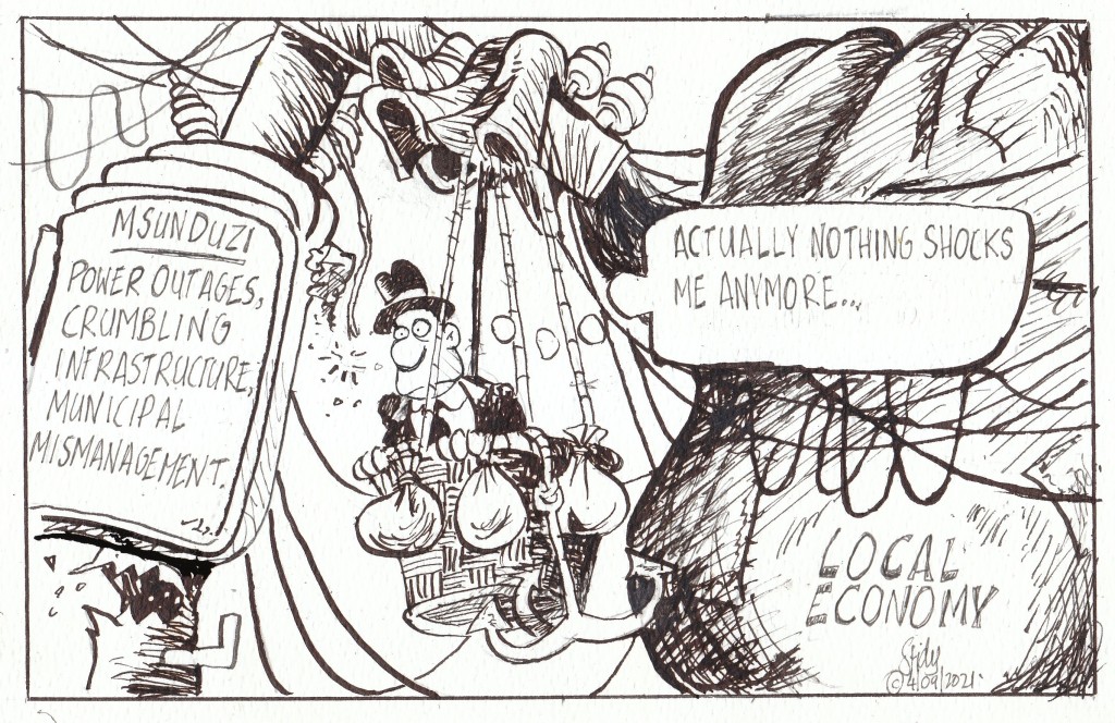
Pietermaritzburg and Midlands Chamber of Commerce CEO Melanie Veness called on the City to protect its electricity structure or risk losing out on investment. She said some businesses in the Mkondeni area were at times forced to go without power for up to two weeks as a result of, among other things, illegal connections. This was having a devastating impact on confidence and some had already relocated to other parts of the country…
The situation in many South African municipalities remained dire with the Auditor-General warning, in a recent report, that the financial situation of just over a quarter of them was such that there was doubt that they would be able to continue operating as going concerns. Leadership instability, poor oversight by councils, significant financial health problems, protests and strikes, a lack of consequences and interventions that were not effective, were all contributing factors to a general inability to deliver services to citizens.
In KZN, the position had been exacerbated by the recent unrest and looting with more than half of its rural towns facing economic devastation.
The National Teacher’s Union (Natu) slammed the KwaZulu-Natal provincial government for using budget cuts as an excuse to deny pupils quality education. Natu acting president, Sibusiso Malinga, said the union would approach the courts should the KZN education department go ahead with plans to retrench 2 000 teachers.
Appearing before the Pietermaritzburg High Court, Jacob Zuma’s advocate, Dali Mpofu, said the former president continued to be “most concerned” by the alleged leaking of his confidential medical information by state advocate Billy Downer. This was but the latest in a long list of arguments put forward by Zuma in his attempts to get the Arms Deal corruption charges against him dropped. The judgement was postponed until 28th October.
Despite damning Special Investigative Unit (SIU) findings against former health minister Zweli Mkhize, his family and his local ANC branch (and President Cyril Ramaphosa himself) rallied behind him. In a report, which the president had sat on for three months, the SIU claimed that Mkhize failed to exercise oversight in relation to the Digital Vibes communications tender awarded to the company by the Health Department.
Delivering the parties so-called corrective manifesto ahead of the forthcoming local elections, President Cyril Ramaphosa promised that this time the ANC will do better. Considering his party has spent almost three decades in power, during which time they have delivered very little of their promises, his assurances were met with a certain degree of scepticism. Elsewhere, the eruption of the Cumbre Vieja volcano on the Spanish island of La Palma intensified, prompting the evacuation of 6000 people.
Various businesses in the Pietermaritzburg area again warned that the prolonged power outages and load shedding were crippling them. The situation was exacerbated by the exorbitant price of electricity in Msunduzi.
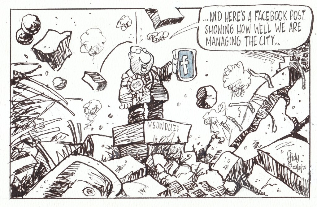
Msunduzi’s attempt to boast about its service delivery achievements was blasted by irate residents who called the city out on its glaring failures. They were responding to a Facebook post where the municipality had a picture of the Moses Mabhida road which they listed as one of their success stories even though it had been funded entirely by the national Department of Transport.
With municipal elections looming in just under a week, Eskom announced it would be implementing Stage Four load shedding because of numerous breakdowns, including a key unit at the Koeberg power station. At a media briefing, public enterprises minister Pravin Gordhan and current Eskom group chief executive Andre de Ruyter both acknowledged the endemic corruption and mismanagement that had plagued the power utility for the last decade. Meanwhile, the latest Citizen Satisfaction Index dropped to a five-year low as South African municipalities continued to fail to meet basic delivery requirements.
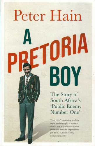
With the benefit of hindsight, it is strange to think that there was a time when the mere mention of the name ‘Peter Hain’ was enough to send the average sports-loving, white South African into an apoplectic fit. Reading his well-written, unflinchingly candid memoir, however, certainly brings it all back home.
From the start, Hain was nothing but contrary. Both of his parents were active members of the South African Liberal Party and as a young schoolboy, growing up in Pretoria, he found himself rubbing shoulders with the likes of Allan Paton and other such luminaries. Inspired by their core principles and selfless example, he rebelled against the country’s official policies at an early age learning, in the process, what it was like to live under constant state surveillance.
Later, Hain’s fierce opposition to Apartheid would see him become not only an irritating thorn in the flesh of the National Party government but also a loathed figure in the eyes of a large portion of their supporters (and a few liberals as well), who saw him as nothing more than a grandstanding, young upstart.
In 1963 Hain’s parents were served with a five-year banning order which restricted their movements and prevented them from entering certain areas. Faced with a ruthless regime that crushed all peaceful protest, many other anti-Apartheid activists began calling for a rethink of tactics. Hain’s parents, however, remained steadfast in their commitment to change through non-violent means but their close friendship with the Johannesburg station bomber, John Harris, brought them under increasing scrutiny by the country’s security services. They were harassed to the point where his father was unable to find employment and although reluctant to do so his family were eventually forced to leave the country.
Exiled to Britain, Hain did not forget his roots nor his steadfast opposition to the South African government and its policies. Mad about sport himself, he knew only too well how important this was to the white South African sense of self. He began organising militant campaigns in the UK against touring South African rugby and cricket sides as his contribution to the struggle. It had the desired effect. In no time Hain found himself dubbed ‘Public Enemy Number One’ by the South African media.
As successful as his tactics were they did not go unchallenged. In 1972 he was hauled before the court on conspiracy charges in a trial that would become something of a cause celebre. After that got thrown out, he would be maliciously framed for a bank robbery. Behind all of this, he sees the malignant hand of the South African Bureau of State Security (BOSS) – with some assistance from elements within MI5 – who wanted to both discredit and neutralise him.
With the release of Nelson Mandela from Victor Verster prison on 11th February 1990, the public perception of Peter Hain underwent a startling metamorphosis. No longer the despised young firebrand of yore (‘Hain the Pain’), his formerly controversial views now became part of – in his words – ‘mainstream opinion.’ To his bemusement, he even had people apologising to him for previously dismissing him as nothing more than a troublemaker.
A career in British politics followed, culminating in him becoming a minister in the Labour government and then getting elevated to the House of Lords.
Wishing only what is best for the country of his birth, Hain has remained true to the values his parents instilled in him. When President Jacob Zuma’s malfeasance was becoming harder and harder to ignore he returned to South Africa and at the behest of several senior ANC members went on to use British Parliamentary privilege to expose the extent of the looting and money laundering. He also testified against Zuma and the Gupta brothers before the Zondo Commission. Nor did he confine his condemnation of wrongdoing to South Africa. As Britain’s Africa minister, he publicly castigated President Robert Mugabe of Zimbabwe for betraying the ideals of democracy and human rights they had both ostensibly fought for.
Part autobiography, part history primer, A Pretoria Boy serves as a salutary reminder, at a time when memories of those dark days have taken on a rosier tint, of just how grim and brutal life was under a regime that used fear to mould human behaviour and where people could be driven into exile – or, in some cases, killed – for expressing dissenting beliefs.
Although Hain displays little rancour or ill will towards his one time adversaries, his book will make uncomfortable reading to many of those he holds to account across the political spectrum.
The urge to migrate, to quest, to go on a journey lies deep-rooted in our DNA. For hundreds of thousands of years before we became sedentary, urban dwellers it was how we lived. We were hunter-gatherers, nomads. I certainly still feel this instinctual pull. It is the reason you so often find me hundreds – sometimes thousands – of kilometres from home and it is why I am always quick to respond to an invitation to do a road trip. For me, there is something magical about going to a place you have never been before and feeling an immediate connection to it.
Thus it was with the Baviaanskloof.
The Baviaanskloof
The Baviaanskloof – ‘Valley of the Baboons’ – lies mostly in the East Cape and is dominated by the Baviaanskloof and Kouga mountains which run parallel to one another in an East-West orientation. Separating the wet coastal belt from the dry interior these mountains form part of a ragged chain that make up much of the South-East coastline of South Africa. Two main rivers drain it, namely the Baviaanskloof and Kouga. They converge at Smitskraal where they travel in an easterly direction to the Kouga dam. The Grootrivier and Witrivier also flow through the reserve and there are a few other minor rivers, streams and odd springs formed where the rare rains come down from the mountains. Here birds and animals come to water.
As a first time visitor to the Baviaanskloof, I was most fortunate to have Goonie Marsh as my guide. Besides making a good travelling companion, he lectures in Geology so was able to explain to my sister Sally and me how this world of marvels came into being. He is also a man with a deep interest in the world around him and as a long time East Cape resident has acquired a great general knowledge of the area.
Goonie Marsh explains how the Baviaanskloof came into being...
Driving down the dusty, twisting, often tortuous road, it is hard to believe there was a time when the climate and landscape were different but some of the Baviaanskloof was once underwater. As part of what is known as the Cape Super Group, its geology consists of alternating layers of sandstone and shale that were deposited on the bed of a large inland sea between 300-400 million years ago. Since then it has been tilted, folded, twisted, faulted, buckled, redeposited in new layers and eroded into its current fantastical shapes (see notes below by Goonie Marsh)*.
Enon conglomerate, Andrieskraal, on which the profile of Queen Victoria can be seen. Made up of quartzite boulders derived by erosion from Table Mountain Group which form the high mountains in the area.
‘The Skull’ – also Enon conglomerates as seen in the Baviaanskloof Cretacious basin. The colour of these sediments is redder compared to Andrieskraal possibly because the latter was open to the ocean whereas these were probably entirely terrestial.
Strata of Table Mountain quartzite which have been pushed vertically, perhaps even overturned.
More Table Mountain quartzite in which the strata are clearly folded – horizontal at the top before flattening out at the base,
We were not, of course, the only nomads, driven by curiosity, to come wandering into this almost mythic landscape. The first anatomically modern humans emerged in the Baviaanskoof during the Middle Stone Age – between 120 000 and 30 000 years ago. They are believed to have been the ancestors of the San who would later live in the area. They left their traces in a large number of caves and overhangs which provided them with both shelter and walls to decorate.
They were displaced and eliminated by the Khoekhoe and early European settlers. Although various explorers and hunters had passed that way before, the first white farmers settled in the Gamtoos Valley in the 1730s. As more arrived, the deeper into the Baviaanskloof they penetrated.
Lonely, sparse and cut off by its mountains from the rest of the world, life could not have been easy for these early settlers. Initial access into the area was by way of an ox wagon. Because of the difficulty of travelling over the terrain, many farmers only made the journey out the valley once a year using the Ouberg track. Getting in and out got just a little bit easier with the construction of a dirt road between 1880 and 1890 by the hard-working, prodigous Victorian road-builder Thomas Bains, son of Andrew Geddes Bains, South Africa’s first geologist and another great road-maker.
Having approached the Baviaanskloof from the East, through the important citrus growing region of the Gamtoos Valley and the towns of Hankey and Patensie, it was along this road that we now travelled. On both sides of us, dry trees rose towards the dusty mountains. Above them would normally hang the hazy blue sky of Africa but – as if to thwart my sunny mood – it was cloudy and cold on our first day. It was still mightily impressive. Here one could sense what the continent must have been like before its wild animals were not confined to a few parks but roamed everywhere and man had not had such an indelible – and, at times, destructive – impact on the environment.
We began by taking a detour off the main road to the Kouga dam. Although a marvel of engineering it made a sorry sight. The East Cape is battling a severe drought with its dams averaging out at only 15% full. At 4,5% of its capacity, the Kouga dam is currently at its lowest level since it was constructed in 1957. Here, like everywhere else, climate change is taking its toll…
Kouga Dam
Dam wall. Pic courtesy of Sally Scott.
It is not always so dry in the valley. Sometimes there are floods. In 1916, for example, over 350mm of rain fell in the catchment area and a great solid bank of water came tearing down the narrow valleys sweeping all before it. Four members of the Campbell family lost their lives when the tree they had climbed to escape the raging torrent gave way under them. There is now a memorial to them.
We spent our first night at Bruintjieskraal in the Rivierspoort, just outside the entrance to the park, on a sheep farm, enclosed in a narrow valley between two ramparts of dark mountain. Our thatched-roofed, timber-framed accommodation proved more modern and more stylish than I had expected, blending seamlessly into the surrounding bush and the mountain itself.
Kudu Cottage, Bruintjieskraal
Sheep, Bruintjieskraal/Glencoe area.
The sky was clearing as we set off the next morning. Pale wisps of cloud danced and dissolved along the mountain peaks casting shifting shadows on the valleys below. After stopping at the Park’s Interpretative Centre (the whole park has now been classified as a World Heritage Site), we followed the road that snakes its way up the Combrink Pass. The higher we went, the more spectacular the scenery got. It was along this stretch of road that we encountered the only other travellers we were to meet in the park – two Germans on motorbikes who stopped to enjoy the same view we did.
Heading towards Combrink Pass.
Combrink Pass. Pic courtesy of Sally Scott.
A fellow traveller.
Near top of Combrink Pass.
At the top of the pass, the country opens up into the extensive Bergplaas grassland plateau which, when we visited, had an almost Alpine feel to it on account of all the swirling cloud, mist and drizzle on its upper peaks. Crossing it, we were greeted by yet more breathtaking views. An interesting oddity here is Winston LeRoux’s rusting, cable system which spans the gaping Waterpoort Gorge. It was once used to link the Enkeldoorn and Bergplaas farming communities and to transport goods between the two but was abandoned in the 1960s.
On the Bergplaas Plateau, looking up to cloud-covered mountains
The old cable system across the Waterpoort Gorge
From Bergplaas we descended the twisting Holgat Pass through more craggy overhangs, clefts and soaring rock The surrounding slopes were covered in fynbos and proteas and – further down – spekboom, aloes (Aloes ferox, africa, speciosa, striata and arborescens all occur in the area) and euphorbia. Strange plants and succulents, that have adapted to vertical living, clutched onto the cliffs. A pair of Black Eagle wheeled overhead.
The Holgat Pass.
The country grew steadily drier the further west we went. In places, the desolation was offset by the dense growth of trees which grew along some of the river banks. The water in these rivers was beautifully cool, clear, tasty and refreshing. In places, pondweed, lilies and something like giant cress grew so thick they looked like little green islands rising out of the water. We stopped at one of the streams, scooping up handfuls of the precious liquid and then sipping it with the all the reverence a person in a parched desert might do.
Drinking from mountain streams.
Lilies.
At mid-morning we pulled into the Smitskraal picnic site for a coffee break. Goonie hauled out his furnace, gathered some kindling, and then fired it up. It was a sight to behold. In no time, the water inside was boiling and the metal contraption was belching out plumes of steam and smoke like an active mini-volcano.
The firing of the furnace…
Coffee break at Smitskraal.
Aside from a bored-looking baboon who watched us from the shade of a tree, we were the only ones around – or, at least, so it appeared. There are buffalo in the park but they must have been lying low that day for we didn’t see any of them although their dung was everywhere scattered across the roads. Black rhino also lurk in the thickets around here but they, too, declined to show themselves. It did not bother me. With their poor vision and small powers of deduction, they are, like the fierce buffalo, notoriously short-tempered. I would prefer not to have a face to face encounter with either and always keep a close eye out for hospitable trees to climb when I am in their presence. Here, unfortunately, the available trees consisted mostly of sharp-needled Vachellia karroo (Sweet Thorn).
An audience of one…note thorns!
There are still leopards living in this mountain wilderness. Maybe one was even watching us from some rock ledge with eyes that see everything but reveal nothing? Cape Mountain Zebra have been reintroduced into the area and there are also Klipspringer, Mountain Reedbuck and several types of highly poisonous snake (including Puff-Adder and the fearsome Cape Cobra). Them I was happy to avoid too…
From the picnic site, we headed up the Grasnek Pass, stopping high up on its neck so I could take yet more photographs of its panoramic view. Pressing on, we passed several tattered and long-abandoned old habitations, disintegrating memorials to those who had tried their luck in this harsh environment before calling it quits. We stopped for a roadside lunch directly opposite one such derelict farmhouse. Looking at its collapsing walls and sun-bleached, corrugated iron roof, I decided it might make a meaningful painting about the fragility and uncertainty of human life (a subject much on my mind since the outbreak of the Covid-19 pandemic) so I hauled out my camera again and photographed it from various angles.
Grasnek Pass
View near the top.
Grasnek Pass
Deserted farmhouse in the Baviaanskloof
Exiting the park we found ourselves back in farmland. Down the hills came herds of goats and sheep, little white flecks against a vast expanse of rock. The scenery remained as majestic as before.
We spent our second night at Speekhout farm, nestling in a vast amphitheatre of mountains with a crocodile-shaped outcrop of red rock at the one end. Sitting outside the flimsy, reed-walled house, that served as our night’s accommodation, with our evening drinks, we watched the dying sun turn the mountain tops gold. Below us, a small band of springbok slipped across a field. Nomads themselves, these buck (once called trekbokke or “travelling buck”) used to migrate across the Karoo in their hundreds of thousands, trampling all before them. Now their movements have been restricted and the few that remain exist mostly behind fences, like these. As a wanderer myself, it was hard not to feel sorry for them.
Speekhout farm, with springbok.
Lying on my own, later that night, in a tent I had found erected around the back of the reed shack, I got to experience just how cold the Karoo can get when the sky is clear and the stars are out. I slept poorly.
The next day we resumed our journey west, heading up through the jagged walls of Nuwekloof Pass which links the western section of the Baviaanskloof with the higher Karoo hinterland and the towns of Willowmore and Uniondale.
The Nuweklood Pass
The moorland-type country, at the top, was covered with low bushes with tough, wiry leaves that can survive where grass cannot. At certain times of the year – like now – little perennial daisy plants pop up all over the place, providing a cheerful contrast to all the greys, browns and ochres. Hardy succulents of many kinds also thrive here, providing additional food for the fat merino sheep who blend in so well with their surroundings.
Blending in with the scenery.
Up here in sheep country, the valleys start getting a lot wider than the mountains they separate. The further west one goes, the more enormous the landscape becomes, and the straighter and emptier the roads. Once you get onto them, it is hard to believe you will ever reach your destination. It certainly felt like that when we hit the N9, about halfway between the towns of Willowmore and Uniondale. Instead of continuing West towards the jagged outlines of the Swartberg mountains, running along the far horizon, however, we turned East again heading back towards the more densely populated Indian Ocean side of the sub-continent.
We stopped in Uniondale for coffee and a quick shop (succulent Karoo lamb was on the menu for that night). The town is famous for, among other things, its ghost, a young woman who stands alongside the same lonely stretch of road we had just driven down. When people stop to offer her a lift she gets in and then scarily vanishes. The story has inspired an Afrikaans film and a song by Andrew Goosen, both titled “Die Spook van Uniondale”.
Uniondale
Uniondale scene
Back on the ghost road, I kept watching out of the corner of my eye but did not see her although, in this deserted landscape, it was quite easy to believe she exists. We passed through Unionpoort and carried on to where the road branches off eastwards, down the Langkloof – the ‘long valley’ that separates the Kouga and Tsitsikamma móuntain ranges – following a long-used route that runs roughly parallel to the one we had been on in the Baviaanskloof.
The Ghost Road with Swartberg mountains in the distance.
A bit of family history here. Many of my ancestors have felt the same, restless urge that had caused me to be cruising down this road. One of them, Benjamin Moodie, the last Laird of Melsetter, had, in 1817, crossed the globe from his home on the Isle of Hoy in the Orkney Islands and set himself up in an old Dutch-style farmhouse at Grootvadersbosch, near Swellendam, at the base of the Langeberg. He was later joined by two of his brothers, John Wedderburn and Donald Moodie. Although he later emigrated to Canada (his two brothers remained, both founding South African dynasties that spread across the country and into neighbouring Zimbabwe). John Wedderburn left an extremely entertaining – and insightful – account of his time in the country in his book Ten Years in South Africa (first published in 1835).
A few years after he arrived, John Wedderburn (who had fought in the Napoleonic Wars and had returned home to find there were few jobs available for ex-soldiers) also came travelling down the Langkloof, en-route to the Grahamstown area where he and his brothers hoped to be granted some land. Like a lot of early travellers on the sub-continent, John Wedderburn found the parched and ancient Karoo a frightening, hostile, place. He was not overly impressed by the more arid and treeless upper parts of the Langkloof even though its fruit growing potential had already been recognised:
“I was much disappointed in the appearance of this tract of country, which, notwithstanding the number of farmhouses and well-watered gardens, was rather bleak and forbidding, from the total absence of wood, and the uniformity of its mountains,” he would later write.
As a Scotsman, he possessed an obvious natural bias towards wet weather and greener pastures and it is only when he reached the coastal end of the valley, where the rainfall is higher and the vegetation more luxuriant, that his opinions began to improve:
“The eastern extremity of the Lange Kloof opens into the valley of the Kromme river; and here the landscape becomes interesting and romantic.”
The greener coastal end – much preferred by John Wedderburn Moodie.
John Wedderburn is generally a reliable guide and I find myself in agreement with much of what he writes but here I am very much at odds with his views. I think the Kouga mountain range, of which he was so dismissive, is an area of extraordinary variety, beauty and – dare I say it? – romance.
Our destination lay in a remote, secluded valley in the Kouga Mountains Wilderness Area. To get to it you have to drive down another rough and lonely road, through a perilously steep gorge and then up the other side. It made for a dizzying, jittery ride.
The road into the Kouga mountains.
The closer you get to the mountains the more impressive they become. Stream beds and ravines trench the foothills. Ahead of the house, in which were to spend the night, a steep gorge cleaved through the mountains, well-wooded in parts, belying John Wedderburn’s thoughts on the matter. In the late afternoon, my sister and I wandered through the peach and apricot orchards which were in full blossom, entranced by the light. Afterwards, we followed up the stream into the mountain gorge. In places, the water flowed straight over the road, so we had to cross on stepping stones.
The gorge in which our guest cottage was situated.
This was, – and still is – Ferreira country. Long before John Wedderburn came riding down the Langkloof, there had been Ferreiras living in the Onder-Kouga. Among these hardy frontiersmen was Johannes Stephanus Ferreira (1848-1896) also known as “Jan Been” on account of his bandy legs (hoepel been), a legacy from his being shot during one of the countless Frontier Wars. According to Bartle Logie, in his book Boots in the Baviaans, Johannes may have been the inspiration for the famous Afrikaans folk-song “Vat jou goed en trek Ferreira” [literal translation: “Take your stuff and move on, Ferreira”]. The romantic in me wanted to believe it was true.
Isolated by its topography it, too, must have been a tough environment to live in although I imagine they must have also developed a strong sense of community still embodied, in many of the Karoo dorps you pass through, by their beautifully built churches, in which the faithful gathered on Sundays. Although in some places houses have been modernised or rebuilt, many of the whitewashed outbuildings are still the same as when they were when constructed.
The church at Uniondale.
Other aspects remain the same. Back doors open up to vegetable gardens which run into orchards which stretch down to sheep paddocks which, in turn, melt into the rough, rock-strewn hillsides. Chickens scratch around in dusty backyards, ducks and geese float on ponds, Border collies snooze in the shade, Ostrich eye-ball you…
In the orchards…
Getting eye-balled by two Ostrich…
Here generations of children have grown up and taken over the running of their parents farm, building on what has gone before.
I was to get further glimpses into the continuity of life in these isolated communities as we headed out along a dirt road that runs along the base of the range the next morning. There are still many working farms in the Onder-Kouga but inter-dispersed amongst them are yet more abandoned old homes which are slowly being reclaimed by the fynbos. The sites of these houses had usually been carefully chosen, often with a mountain as a backdrop and a view that looked on to yet another mountain.
A working farm.
A deserted farmouse…
and another…
…and another.
Having crossed the Kouga river yet again we found ourselves back on R62, near Kareedouw where we stopped for more coffee…
And so my journey into the Baviaanskloof came to an end. As we headed back to Grahamstown, along the N2, I realised that travelling through it had been far too big an undertaking for me to be able to give anything other than a shallow summing-up of my thoughts, impressions and experiences. Nevertheless, I still emerged from the journey feeling I had learnt a little bit more about my country and – just as important if travel is to prove redemptive – myself.
My life had been both broadened and enriched by my foray into the Valley of the Baboons…
GALLERY:
Aloe ferox. Baviaanskloof.
Aloe ferox near Uniondale.
Sombre Greenbul.
Blue Crane.
Ostrich
Cape Bunting
African Black Duck.
Old boots abandoned on side of road.
Sheep sheltering in shade.
Ruined house.
Conglomerate.
Lunch break in the Baviaanskloof.
Kouga mountains.
More fold mountains, Baviaanskloof. Pic courtesy of Sally Scott.
*NOTES ON CAPE FOLD BELT
by Goonie Marsh
The Cape Fold Belt has a long history starting about 500 million years ago with the
formation of a shallow marine basin, the Agulhas Sea, along the southern margin of
Gondwana, a single land mass or supercontinent, which was made up of the continents
currently known as Antarctica, Australia, India, Africa and South America.
For the next 170 million years until about 330 million years ago, this basin received sandy
and muddy sediment derived by erosion from the interior of Gondwana. With compaction
and cementation the accumulated sediment formed a succession of sandstones and shales
more than 8 km in thickness. This succession is known in formal terminology as the Cape
Supergroup and it is subdivided into 3 major units depending on the proportion of
sandstone to shale in the sequence. The oldest and lowermost unit is the Table Mountain
Group which is dominated by quartz sandstone of exceptional purity. This is overlain by
the Bokkeveld Group which has thick units of shale interleaved with thinner sandstone
layers. The topmost, and therefore youngest unit, is the Witteberg Group with
intercalated shales and sandstones in approximately equal proportions.
Starting about 330 million years ago and continuing for over 100 million years, the
southern margin of Gondwana was subjected to powerful laterally compressive forces
directed northwards. These forces destroyed the Agulhas Sea and Cape Basin, squeezing it
against the continental mass of Gondwana, rumpling, folding and uplifting the sedimentary
strata that had accumulated to form a major fold mountain belt, the Cape Mountains. The
folding process also fuses the grains in the rocks tightly together and they harden,
particularly the quartz sandstones, which are converted into exceptionally hard quartzites.
The general processes and products of this fold mountain building event are known as the
Cape Orogeny. A good ‘modern’ analogy would be the creation of the Himalayas – Earth’s
still active major fold mountain chain formed by India pushing into Asia
ACKNOWLEDGEMENTS:
Baviaanskloof – A World Untouched. Compiled by Liesl Hattingh (published by Baviaans Tourism).
Boots in the Baviaans by Bartle Logie (Bluecliff Publishing).
Ten Years in South Africa by Lieut. J.W.D Moodie published by Richard Bentley)
SPECIAL THANKS to Goonie Marsh and Sally Scott for organising this trip and being happy to stop whenever I wanted to take a photograph – which was very often – or have a cup of coffee…
The Constitutional Court sentenced former president Jacob Zuma to 15 months imprisonment for defying its order to appear before the Zondo Commission to give evidence on state capture. In its judgement, the ConCourt gave police minister Bheki Cele three days to arrest Zuma should he fail to hand himself over to the police within five days.
Jacob Zuma finally surrendered himself to police less than an hour before midnight on Wednesday 7th July after a night of high drama during which a phalanx of heavily-armed police units was on its way to arrest him at his Nkandla home. The disgraced former president, who oversaw a decade of state capture and decline, spent his first night at the Estcourt prison after high-stakes-cat-and-mouse negotiations with the police.
In a week that marked the darkest point in South African history since independence, large parts of KwaZulu-Natal and Gauteng found themselves at the mercy of marauding gangs of looters, ostensibly protesting the imprisonment of former president Jacob Zuma. Extremely tardy in their response, the security cluster ministers would continue to insist the situation was being contained despite numerous lives being lost and billions of rands worth of property destroyed. President Cyril Ramaphosa, would, to his credit, later admit the Government had been caught unprepared.
While fire-fighters, private security companies and local communities joined forces to try and protect the towns and cities, the ANC government was slammed for failing to be more visible on the ground while the country was gripped by riots and looting that brought the economy to its knees. Its slow and poor response was later blamed on budget cuts, poor intelligence and rifts between the security cluster ministers. Visiting the Liberty Midlands Mall in the aftermath of the wave of unrest, Police Minister Bheki Cele belatedly acknowledged the extent of the damage and warned that the country was “not out of the woods” even if it appeared on the surface that life was returning to normal.
President Cyril Ramaphosa’s assurance, to the nation, that his government would “leave no stone unturned” in its efforts to bring the anarchy that played out across parts of the country to an end seemed unlikely to convince a sceptical public, long inured to the ANC’s empty promises. This was especially so as most of the prime instigators behind the unrest came from within the party itself and the ANC had always shown a marked reluctance to deal with its wrongdoers.
Msunduzi Municipality warned that it might not be able to assist businesses that were affected by the unrest. With some of its commercial customers having had their businesses looted and destroyed, the municipality was also unlikely to collect the revenues it had estimated at the start of the 2021/22 financial year and this could also severely impact its ability to deliver services – already under strain as a result of the ongoing Covid pandemic.
Appearing before the State Capture Enquiry President Cyril Ramaphosa spent much time trying to avoid directly implicating ANC members in state capture. He did, however, admit that ANC factionalism had debilitated its ability to fight corruption because it led to people having “vested interests in maintaining certain activities.”
Following reports that KwaZulu-Natal schools had emerged as the biggest contributor to the rapid increase in Covid-19 cases in the province, there were calls for the closure of those most badly hit. According to KZN Premier Sihle Zikalala, more than 120 schools had reported clusters in their school settings and more than 800 teachers and learners had been affected. Learners made up 95% of the number, while educators accounted for the remaining 5%.
The Msunduzi Municipality Council agreed to sponsor Maritzburg United FC to the tune of R9 Million for the next three years despite warnings from opposition parties that it could not afford the expenditure. Questioning where the council’s priorities lay, the Msunduzi Association of Residents, Ratepayers and Civics (MARRC) said they would be seeking legal advice.